Release Notes
Discover new features, improvements, and fixes in PVGround.
Version 1.331
September 27, 2026PVGround 1.331 takes your site from rainfall to foundations without leaving CAD: design the complete drainage, draw sections that match the real build and get earthwork volumes you can hand to the contractor with confidence — plus Adaptive Spacing, BESS foundation details and a faster, cleaner interface.
New Features
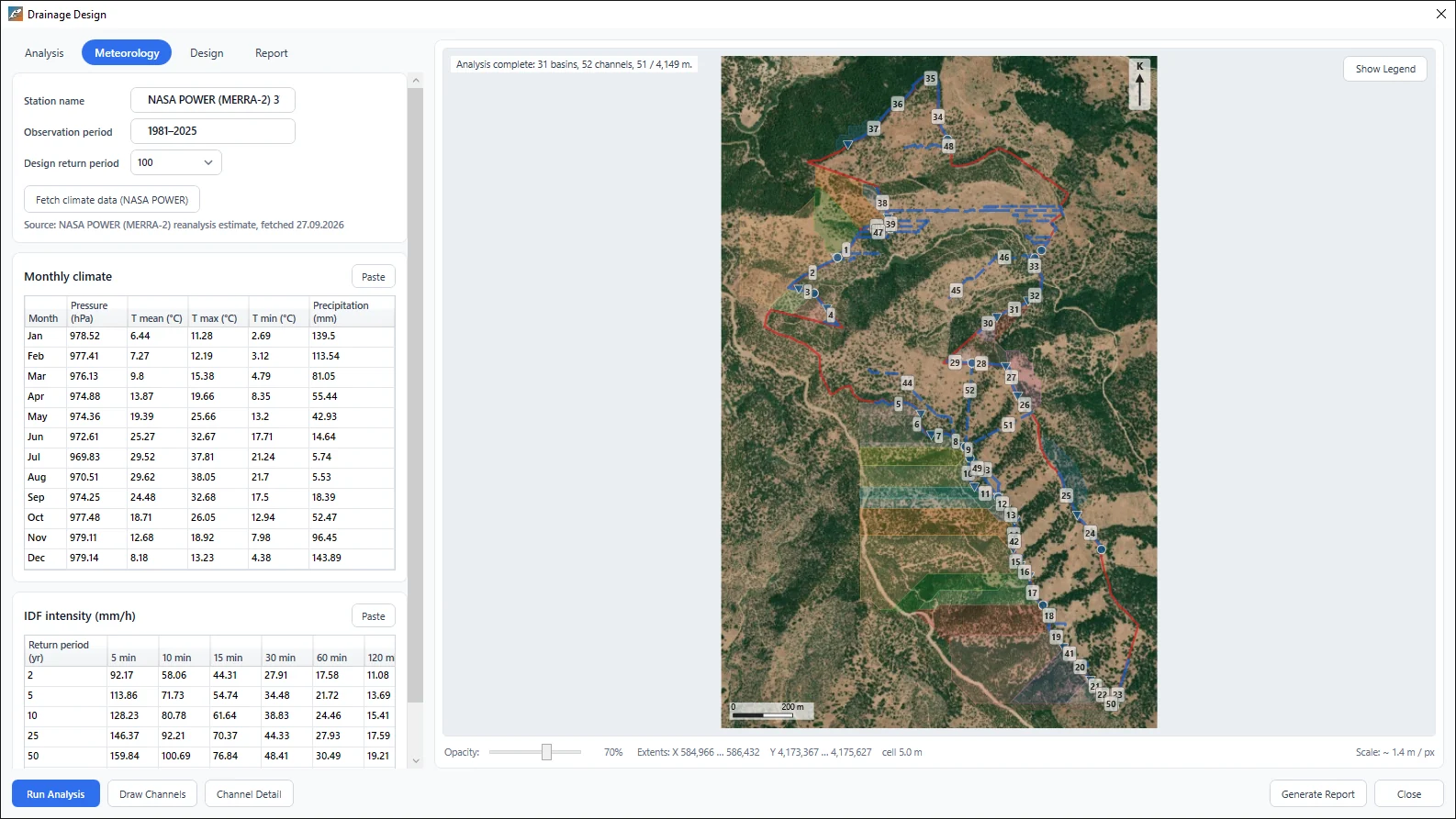
- Drainage Design
- Design the complete site drainage inside PVGround — no separate hydrology software, no spreadsheets.
- Catchments, peak flows and channel sizes come from IDF design storms, and your site's climate data fills in automatically from NASA POWER.
- Buried pipes and culverts are picked from a pipe catalogue and routed along the parcel–PV corridor to real discharge points.
- Hand over CAD channel drawings, detail sheets with terrain sections and a full PDF report — generated in the background, password-protected and stamped with its origin on every page.
- The site in the screenshot — 31 basins over 103 ha — was analysed in about a second.
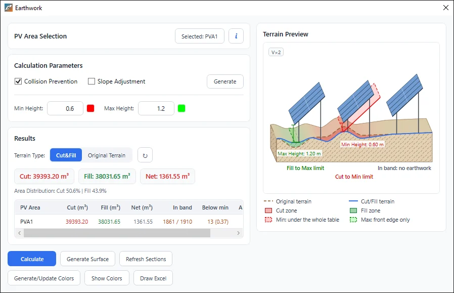
- Cut & Fill — Slope Adjustment and Membrane Grading
- Earthwork volumes you can defend: clearance is measured from the module underside, so tilted tables are no longer treated as flat.
- Membrane grading is the new default — no ripples, no terraces, less soil to move. In the screenshot, 1,861 of 1,910 tables stay inside the clearance band and cut and fill almost balance.
- Slope Adjustment grades along each frame axis instead of forcing one slope on the whole site.
- Every PV area gets its own clearance band summary, a 2.5D preview explains the grading before you apply it, and Calculate no longer freezes.
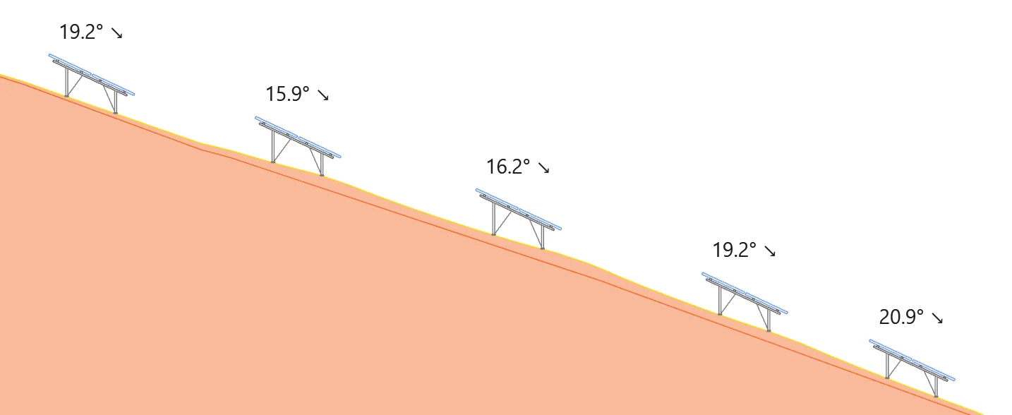
- True-Scale Section Views
- Sections that look like the real build: fixed-tilt and tracker structures drawn 1:1, with real module thickness, motor and joint gaps.
- Cut across several PV areas at once; a surface legend separates original and graded ground, and piles break at their own ground line with the real embedment depth.
- Side labels show the terrain slope, and Refresh Sections brings stale sections up to date in one click.
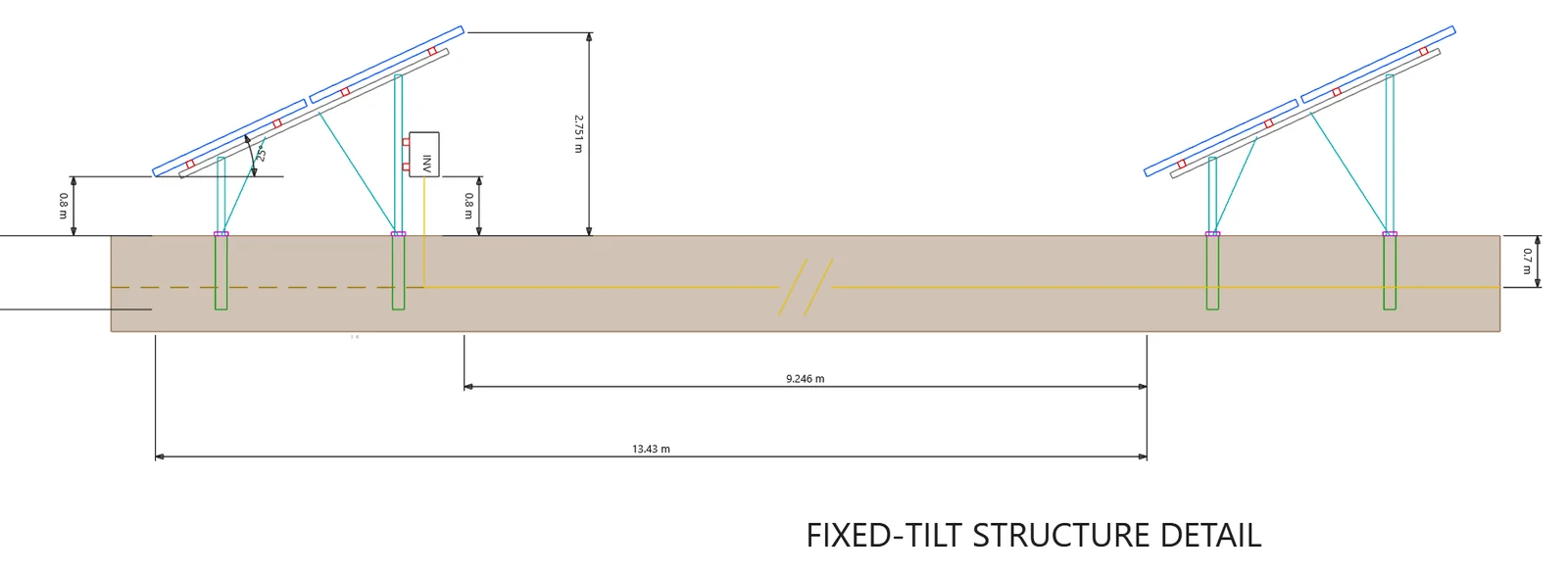
- Draw Structure Detail
- Right-click a fixed-tilt frame and get a dimensioned structure section for your drawing set.
- Heights, tilt, spacing and cable depth are native AutoCAD dimensions — edit them like any other.
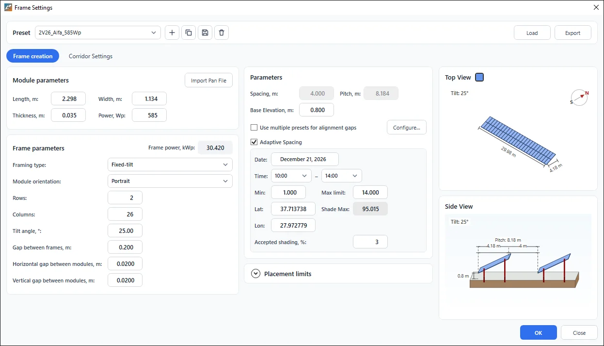
- Adaptive Spacing
- Tell PVGround how much shading you accept — or give it a fixed pitch — and every row is spaced for your site, using NOAA sun positions for the date and hours you choose.
- Frame Settings opens instantly; the heavy shading calculations run in the background.
- BESS — Cabling and Foundations
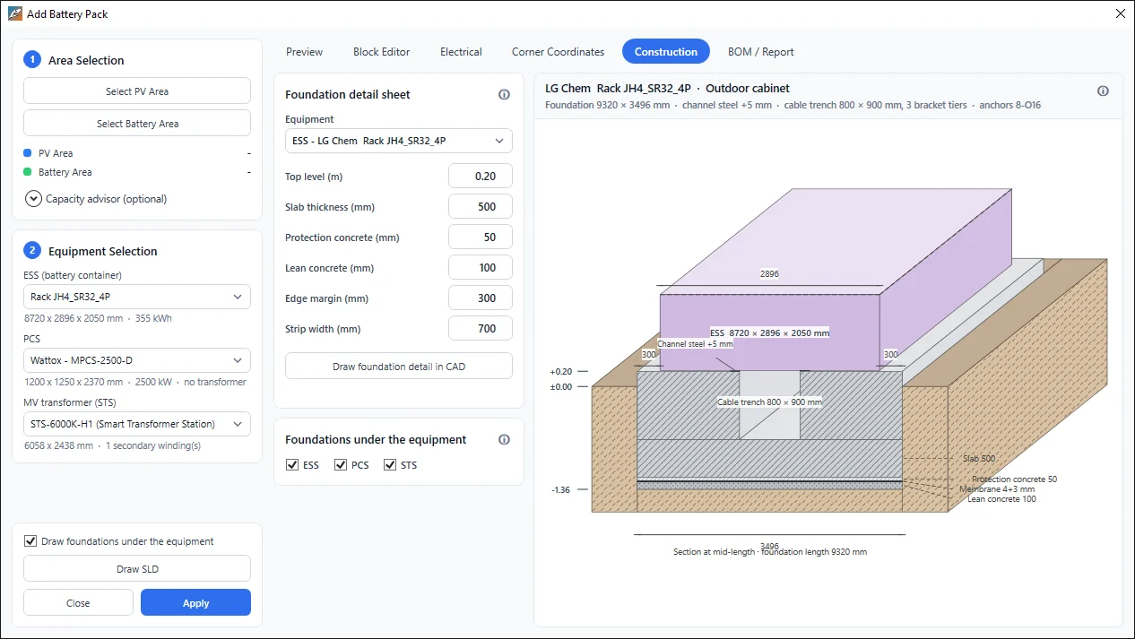
- Route the DC and AC cables inside the battery block instead of drawing them by hand.
- Equipment-specific foundation detail sheets with a 2.5D section — slab, channel steel, cable trench and anchors — ready to draw in CAD; STS units face the service road.
- A simpler Battery Pack dialog: counts and clearances live in the Block Editor, and side-by-side PCS units share one foundation.
- Full Auto Electrical Layout
- Full Auto now takes on large sites split by corridors and inherits the Build lattice.
- Station zones never straddle an exclusion zone, and small islands join a neighbouring station.
- The AC backbone follows the parcel boundary — no AC cable is left outside a trench.
Improvements
- Elevation you can trust: a coordinate error that could sample terrain up to 165 m off-site is fixed, so slopes are right from the start; Google Elevation and Mapbox Terrain-RGB are now the primary sources.
- Base elevation is now a target, so frames no longer step down or sink into the ground.
- Adapt Frames filters by layer and adapts shading objects too.
- Tree species set the canopy height and get their own plan symbol; CCTV cameras can be placed along a polyline.
- Every dialog moved to a compact card layout, with pictures from the product in the info badges.
- PV Area identity survives your edits, and 3D polylines convert straight into PV areas.
- DC 3D cabling: better corridor ranges and cleaner surface transitions between trenches.
- Terrain shows as 3D Face by default, with point-by-point import progress.
Bug Fixes
- AR-SAND hatch now shows in AutoCAD section views, and Profile Front no longer freezes.
- Tracker section tables are no longer erased when sections are redrawn.
- Fixed the inner gap between frames on cross-slope terrain; exclusion-zone arcs are cut correctly.
- More robust plugin loading (NETLOAD).